Sunday, July 31, 2011

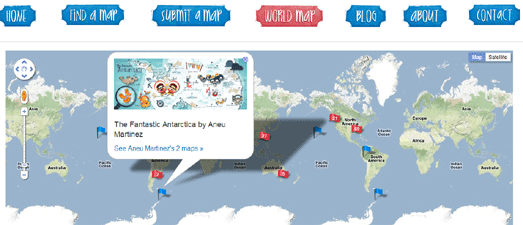
Google Maps of the Week

They Draw & Travel - World Map

They Draw & Travel is a collection of wonderful user submitted hand drawn maps.

The World Map lets you browse the maps submitted to They Draw & Travel on Google Maps. You can click on any of the map markers and view the hand drawn map submitted for that location.

One Day on Earth

On 10.10.10 One Day on Earth asked people around the world to create a video of their world. The goal of the project was to "create an open shareable archive and documentary film of the world on 10/10/10."

You can browse and watch the thousands of videos that were contributed around the world on this Google Map.

#rorschmap

I only found this map yesterday and it has already become a firm favourite.

#rorschmap uses the Google Maps API to create a kaleidoscope for any location on the Earth. Essentially the application displays the Google Maps satellite view of a location and, using the same principle of multiple reflection that you find in kaleidoscopes, creates an animated Rorschach test effect.

________________

Saturday, July 30, 2011

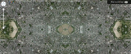
The Amazing Google Maps Kaleidoscope


I bet the first think you did when you first discovered Google Maps was to look at your house in satellite view. It has taken a while but finally you can now go a step better and view your house in kaleidoscope view.

#rorschmap uses the Google Maps API to create a kaleidoscope for any location on the Earth. Essentially the application displays the Google Maps satellite view of a location and, using the same principle of multiple reflection that you find in kaleidoscopes, creates an animated Rorschach test effect.

The result is pretty fantastic. You can even turn the automated animation off and drag and pan the map to create your own kaleidoscope views. You can even use the search function to create 'rorsch maps' for any location in the world.

#rorschmap

________________

World Tour Schedules on Google Maps


Artist / DJ Richie Hawtin has created a gorgeous looking Google Map for his current world tour. Custom map tiles have been used to give the map a distinct design. The dot-matix look of the design is continued in the custom made map markers and information windows.

Dates on the tour are displayed on the map and a slide-out sidebar shows the dates in list form.

The 'One City' world tour continues until December.

________________

Friday, July 29, 2011

Real-Estate Heat Map


Real-estate website Zoopla has created a heat-map of UK property prices.

The Google Map provides a quick overview of where properties are affordable and where houses are more expensive. For example if you zoom in on London, you can see a distinct pattern of expensive property in the commuter belt around the capital.


Zoopla: UK Property Heat Map

________________

Geohashing with Google Maps


The xkcd Geohashing Wiki is inviting you to participate in the wonderful world of random location meet-ups.

Geohashing is a method for finding a random location near your current location and then visiting it. Every day the geohashing algorithm generates a new set of coordinates for your location. Everyone in a given region gets the same set of coordinates.

After you have visited the random location you can document your expedition on the Geohashing Wiki, including details of who was involved in your expedition and pictures of your adventure.

To get your daily randomised coordinates visit the Geohashing Google Map. Click on the map to show your location and, using the geohashing algorithm, your random location will be generated by the map.

Geohashing Wiki

________________

Livebookings Live on Google Maps


Online clothes retailer Zappos started a trend when they created their live Zappos Map. This real-time map was created to show the latest orders placed on Zappos live on a Google Map.

The Zappos Map was quickly followed by Net-a-Porter Live, ThisNext and The Book Depository Live. Now Livebookings, Europe’s largest online booking service for restaurants, has released a live map of restaurant tables booked by its customers.

Livebookings Live takes the reservations coming in, removes the customers' names, and plots them on a map showing where, for how many, and with what frequency the Livebookings system is used.

Livebookings Live Map

________________

Thursday, July 28, 2011

Google Hotel Finder Arrives


Google has today launched Hotel Finder, a new search tool to help you find a hotel.

The tool includes an interesting Google Maps interface that allows you to search for hotels by location. When you enter a location into the Hotel Finder the map shows an initial shape based on the most popular area for visitors to stay. Users can drag the shape to define more closely this area, e.g. close to the ocean or along Sunset Boulevard.

Hotel Finder also shines a "tourist spotlight" on the most visited areas in the selected city. Tools in the sidebar allow you to adjust the price of hotels you wish to view on the map and to compare the current price to the hotel's typical price.

Via: Inside Search

Google Hotel Finder

________________

Russian Greenpeace on Google Maps


Greenpeace has released a Google Map of recycling stations in Moscow.

The map shows the locations of recycling stations for paper, glass, plastic bottles, old electronics and clothing in the Russian capital. The map includes custom made markers that are colour coordinated to indicate the type of recycling possible at each station.

It is also possible for users to add the location of missing recycling locations to the map.

Greenpeace - Moscow Recycling Map

________________

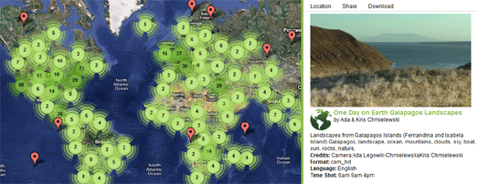
One Day on Google Maps


On 10.10.10 One Day on Earth asked people around the world to create a video of their world. The goal of the project was to "create an open shareable archive and documentary film of the world on 10/10/10."

Whilst you wait for the finished full-length film to be released you can browse and watch the thousands of videos that were contributed around the world on this Google Map.

If you click on a map marker you can watch the selected video in the map sidebar. For each video you can view details, such as where and when it was shot and who by.

One Day on Earth

________________

Tube Directions Now On Google Maps


Public transport directions for London has been added to Google Maps. If you want to get around in London you can now get transit directions that include the London Underground, DLR, buses and trams.

To get public transit directions in London on Google Maps you just need to select 'Get directions', type in your starting point and destination and click on the train icon that appears in the side panel.

The resulting direction will then tell you which underground station you need to go to and even which tube line you need to catch.

Official Google Blog

________________

Wednesday, July 27, 2011

Hand Drawn Maps on Google Maps


They Draw & Travel is a collection of wonderful user submitted hand drawn maps.

As part of the launch of the website a Marvellous Map competition was held with a grand prize of $1,000 for the winner and 5 runner-ups each receiving $200. The six winners of the competition will be announced on Friday.

The World Map lets you browse the 225 maps (so far) submitted to They Draw & Travel on Google Maps. You can click on any of the 225 map markers and view the hand drawn map submitted for that location.

They Draw & Travel - World Map

________________

London Olympics Tweet Map


There is one year to go to the 2012 London Olympics. A number of events are being held in London to celebrate the occasion (including the flying of musical hot air balloons).

CASA is tracking all of today's Twitter messages that include the hashtag '1yeartogo' and have created a nice heat map of all the Tweets.

The map is actually a little sneak preview of a new heat map visualisation that will be made available to the general public in the next few weeks on MapTube. CASA are responsible for some of the best Google Maps tools (for example the CASA Image Cutter) so I can't wait to play with this new heat map tool when it is released.

#1yeartogo Twitter Map

________________

Live Symphonic Balloon Tracking


London has today entered into the fantasy world of steampunk. In what seems like an episode from 2D Goggles a number of hot air balloons have been flying over London blasting out music to the populace below.

Don't worry if you don't live in London or if you have missed any of the balloons' flights as you can replay it all on a handy Google Maps based application.

The map shows each of the hot air balloons and their flight track. If you click on the map marker of any of the hot air balloons you can then listen to the music that was played during the flight.

Sky Orchestra

________________

Tuesday, July 26, 2011

Australian Social Diversity on Google Maps


Arek of the All Things Spatial blog has created a series of Google Maps to highlight social diversity in New South Wales, Australia.

The Australian Bureau of Statistics attempts to quantify socio-economic diversity for geographic locations with a suite of four summary measures called Socio-Economic Indexes for Areas (SEIFA). Arek has imported the Bureau's data for the four measures into Fusion Tables and created a map for each.

Each map provides a heat-map visualisation of one of the measure. In each map you can click on any of New South Wales' postal areas to view the area's rank and decile.

________________

Taking Flight with Google Maps


General Electric's Points of Departure is a nicely designed Google Map showcasing the 6,000 most popular airports in the world. You can browse the airports by name, by the busiest airports, the most scenic or even view those situated on small islands.

Each airport is shown with Google Maps satellite view. Pictures from Flickr are also displayed beneath the map and their location shown on the map with map markers. The map also includes a permalink buttom that allows you to share your favourite map view.

The GE Show: Future Flight: Points of Departure

________________

Munich's S-Bahn Live on Google Maps


I'm a great fan of live real-time maps of city transit systems. There is something about watching trains moving in real-time on a map that really appeals to my inner geek.

This real-time Google Map of Munich's S-Bahn shows the transit system's trains live as they move around the city. Each train is represented on the map with a numbered map marker indicating which line it is travelling on.

You can click on any of the train markers and view its next stop and its destination station. It is also possible to click on any station on the network and view the times and destination of the next trains scheduled to arrive.

S-Bahn Munich: Real-Time Map

________________

How to Make a Campus Map


Loughborough University's campus map is a great example of how to use the Google Maps API to help students and visitors find their way around a large campus.

The map uses the custom overlays function to overlay a custom map of the university on top of the Google Map. The custom map overlay includes features and locations that are not on Google Map's own map tiles, such as trees, tennis courts, football pitches etc.

The map also makes good use of polygons to make buildings on the map interactive. If you click on any of the buildings you can view the building's name, a photo of the building and links to its page on the university's website.

Finally, the map includes a very nice search facility that allows you to search for a building or feature by name or by category.

Loughborough University Campus Map

Hat-tip: Michael Lee

________________

Monday, July 25, 2011

America's Hate Groups on Google Maps


The Southern Poverty Law Center has created a Google Map of active hate groups in the United States.

The map displays the location of 1,002 hate groups throughout the U.S.. The list was compiled using hate group publications and websites, citizen and law enforcement reports, field sources and news reports.

Using the map it is possible to select a U.S. state and view all the state's recorded hate groups on the map. A list of the hate groups is also displayed under the map. The hate groups are categorized by city and by type.

Southern Poverty Law Center - Hate Map

________________

Personal Trip Itineraries with Google Maps


GoPlanit is a travel planning tool that can create personalized trips for a number of U.S. cities.

To start planning your trip you need to select the city that you are visiting. Then you choose the types of activities that you are interested in from; attractions, night life, arts & culture, romantic, kids, shopping, nature and tours.

GoPlanIt then automatically (and very quickly) creates an itinerary for each day of your trip based on your requirements and a Google Map highlighting all the recommended places to visit.

Once you are satisfied with your personal itinerary you can then print out maps, all contact information, notes, and pictures. You can even access your itinerary and map directly from your mobile phone.


GoPlanIt

________________

Sunday, July 24, 2011

The Pick of this Week's Google Maps

Met Office: Storm Tracker

The UK Met Office has created a new Google Maps based application to monitor and forecast tropical cyclones around the world.

The application allows you to view worldwide cloud conditions and the locations of current cyclones. If you select a cyclone on the map you can view the cyclone's observed track and wind speeds recorded along the track.

As well as viewing current tropical storm conditions it is also possible to view historical storm information. For example you can view the track of the 2005 Hurricane Katrina.

MyBlocNYC

MyBlockNYC is a Google Maps based application that allows users to upload and explore videos documenting the life and culture of New York City.

The site already boasts nearly 1000 videos and videos representing 734 New York City blocks. The blocks that have videos are displayed on the map with yellow roads. If you click on a yellow line you can watch the video directly from the map.

As well as exploring the videos by location you can filter the results by category, by time of day and season, and by the age and sex of the film-maker.

Geotrio

Geotrio is creating a world-wide library of mapped audio tours that can be accessed from smart phones and desktop computers. Using Geotrio users can create, browse and share digital audio tours for any location in the world.

Each uploaded tour includes a Google Map of the audio tour. The map includes markers for each stop and each stop contains an audio commentary of what you can see at that location.

________________

Saturday, July 23, 2011

A Google Map of School Immunizations


The Chicago Tribune has analysed state data for clusters of children without the required vaccinations at public and private schools in Illinois. These clusters seriously raise the chances of school-based outbreaks of serious preventable diseases like measles and whooping cough.

To accompany the analysis the Chicago Tribune has created a Google Map that lets you search for individual schools and view the percentage of students at the school with the recommended immunizations.

The map also shows hotspots where schools don't meet these recommendations.

2010-2011 School Immunization Map

________________

Google Maps API Premier - A Review

Michael Lee, an MBA student at the University of Durham, is currently carrying out a review of Google's geospatial products. The review is particularly looking at ways of improving Google Maps for business users.

If you have any knowledge of the Google Maps API Premier service Michael would love to hear from you. Please contact Michael if you have any experience of using the API or if you have any ideas about how it could be improved.

To help Michael's review you can complete this survey or contribute to the forum Michael has created.

If you want to know a little more about the project you can read more on the project's website.

________________

Audio Tours on Google Maps


Geotrio is creating a world-wide library of mapped audio tours that can be accessed from smart phones and desktop computers. Using Geotrio users can create, browse and share digital audio tours for any location in the world.

Each uploaded tour includes a Google Map of the audio tour. The map includes markers for each stop and each stop contains an audio commentary of what you can see at that location.

Geotrio is available as a free iPhone app so you can listen to the audio tours whilst actually walking the route of the tour. If you are more of an armchair tourist or you are interested in listening about locations that you can't visit you can also access the tours from your desktop computer.

Geotrio

________________

Friday, July 22, 2011

New York Videos on Google Maps


MyBlockNYC is a Google Maps based application that allows users to upload and explore videos documenting the life and culture of New York City.

The site already boasts nearly 1000 videos and videos representing 734 New York City blocks. The blocks that have videos are displayed on the map with yellow roads. If you click on a yellow line you can watch the video directly from the map.

As well as exploring the videos by location you can filter the results by category, by time of day and season, and by the age and sex of the film-maker.

MyBlocNYC

________________

Copenhagen Bike Parking on Google Maps


Anyone who has ever visited Copenhagen won't be in any doubt about how much its inhabitants like to cycle. It is said that at least 36% of all Copenhagen citizens commute to work, school or university by bicycle.

The city council of Copenhagen has released open data showing all of the bike parking locations in the city. Soren of microformats.dk imported the data into Fusion Tables and, in less than ten minutes, he created this Google Map of bike parking locations.

The map shows 4,190 bike parking spots throughout Copenhagen, with space for 48,115 bicycles to be parked. This would probably be more than enough for most cities, however with half a million people owning bikes in the city it means that many citizens still can't park their bikes in official spots.

Soren hopes that his map will be used by those campaigning for more bike parking locations to identify those areas that need more bike parking spots.

Copenhagen Bike Parking Map

________________

Thursday, July 21, 2011

The Worldwide Tropical Storm Tracker


The UK Met Office has created a new Google Maps based application to monitor and forecast tropical cyclones around the world.

The application allows you to view worldwide cloud conditions and the locations of current cyclones. If you select a cyclone on the map you can view the cyclone's observed track and wind speeds recorded along the track.

As well as viewing current tropical storm conditions it is also possible to view historical storm information. For example you can view the track of the 2005 Hurricane Katrina.

Met Office: Storm Tracker

Finding a Hotel with Google Maps


If you are looking for somewhere to stay on your vacation or business trip then bedmap's hotel based search application can help you find the ideal hotel.

Bedmap uses Google Maps to help you search over 90,000 available hotels worldwide. Using the map you can search for a hotel by location and filter the results by a large number of requirements, for example the availability of free wi-fi, room-service or free parking.

The map markers for each hotel display the current room rates, so it is possible to instantly compare the cost of rooms. The map also includes a drop-down menu that allows you to change the currency that the markers display.

bedmap

________________

Create a Google Map in Minutes


Topo.ly is a free Google Maps creation tool that you can use to create a map from data from a spreadsheet, for example from data in an Excel spreadsheet.

Using the tool it is very easy to create a Google Map with multiple dataset layers, apply filters to locations, choose different markers and securely share maps within a team.

You can register for free with Topo.ly. Then all you need to do is name your map and then paste a list of addresses into the map creation tool. Within seconds, all addresses and other location-specific data is plotted on a Google Map.

Topo.ly

________________

Wednesday, July 20, 2011

New York Apartments on Google Maps


Renthop is a great rental apartment finder for New York. Using the Google Maps view it is possible to search for properties by the usual location, number of bedrooms and price filters.

Renthop, however, also includes a number of other useful search criteria. Rentop allows you to also search for properties that have no fee, a doorman, an elevator, a fitness center, a laundry in the building, a roof deck, cats allowed and dogs allowed.

If you are in the lucky position that you can actually afford to buy your own apartment in New York you can also use rentop's sister site realtyhop.

Renthop
Realtyhop

________________

Bulgarian Real Estate on Google Maps

Cheap Bulgarian House

If you are looking for property in Bulgaria then Cheap Bulgarian House is a good place to start.

The site uses Google Maps to display a large number of properties for sale or rent in Bulgaria. It is possible to search the map by price range, by type of property, by location and by the size of the property you want.

Properties from Bulgaria

This Google Maps mashup shows properties for sale or rent in the major Bulgarian towns.

The map sidebar provides quick links to view properties in specific towns. Underneath the map it is possible to select which types of property you wish to view.

Each information window includes a photo of the property and a link to more details.

Varna Plan

Varna Plan is a Google Maps mash-up for the Varna area in Bulgaria. Thanks to the map's impressive area polygon selection search engine it is possible to view an incredible amount of data about Varna on the map.

The map displays commercial, rental and residential property for sale in Varna. It is also possible to view from a large selection of tourist related layers.

________________

Tuesday, July 19, 2011

Building Outlines in More Cities

Google have today added 3D buildings to Google Maps in more cities around the world. The new cities include London, Paris, Barcelona, Stockholm, Singapore, Lisbon, Boulder, and 11 major cities in South Africa.

In Google Maps the 3D buildings look pretty cool but they really only come to life on Google Maps for mobile. On Google Maps for mobile you can rotate, tilt, and zoom in and out on the buildings.

My guess is that at some point soon Google will look to implement the rotate and tilt views in Google Maps for the desktop.

The rotating buildings obviously make more sense on mobile maps where the orientation of the map can rotate to reflect your view. However this would be a great feature to be able to access via the Google Maps API. I could see this being a popular tool with many map developers.

Via: Google LatLong

_________________

Boston's Elastic Boundaries on Google Maps


Like many big cities Boston has very fluid neighborhood boundaries. Two people living next door to each other can often have very different ideas of which district they live in.

To try and clear up some of the confusion around Boston's boundaries Boston.com has created a Google Map that shows the different boundaries used by the Boston Redevelopment Authority, by the police, by the city and those determined by zip code.

Using the map you can drag the map pin around to view the different district boundaries at different locations.

Exploring Boston's Tangled Boundaries

_________________

New Look for Google Maps

Google has made some design changes to the map tiles in Google Maps.


There seem to be a lot of subtle changes to map features, including:

Brighter colors
Highway shields integrated into the road labels
Changes to the way tunnels are presented
Changes to the highlighting on place names
Changes to land parcels and building outlines

Interestingly Bing Maps also made some changes to their design last week.


I think the design of Bing Maps has improved a lot over the last year but Google Maps still looks much cleaner and more legible to me.

Via: Google LatLong

_________________

Guess a Street View


Locatestreet is a Street View guessing game.

The premise of the game is simple. Locatestreet places the player in a random location using Google Maps Street View. The player then has to determine his or her location.

Along the way, the player can use helpful clues, examine random Wikipedia articles relevant to the places they virtually visit and share their favorite random locations with other users.

It is currently possible to play in the United States and Mexico, and other countries will be added in the coming days and weeks.

Locatestreet

_________________

Monday, July 18, 2011

Hydrothermal Vents on Google Maps


This is our second foray into subterranean (or should that be submarine) mapping today. However, whereas Greg's Cable Map maps the world's undersea telecommunications cables, Peter Aldhous' Google Map shows the locations of deep sea vents.

Peter's map displays all known hydrothermal vent fields. The map uses color-coded map markers to show active and inactive vents. The map also shows plate boundaries and exclusive economic zones.

Hydrothermal Vent Fields Map

Via: SmartPlanet

_________________

How Countries Change on Google Maps


Here are two great Google Maps applications for anyone interested in history or genealogy. The applications allow you to view the changing boundaries of different countries and U.S. counties over time.

The Historical World Boundary Map application displays world political boundaries from 1946-2008. You can click any country on the map to view how its boundaries have changed over time.

The Historical County Boundary Map displays U.S. county boundaries for any historical year. You can click any county on the map to see the specific history of the boundary changes, and navigate through different years to see the boundary changes of the county over time.

Historical County Boundary Maps
Historical World Boundary Maps

_________________

Undersea Cables on Google Maps


Greg's Cable Map is a Google Map of the world's undersea communications infrastructure. The map displays the major cables that allow internet and other data to travel from the other side of the world, across the oceans and into your home.

It is possible to click on any of the displayed cables (or select it from the side menu) and view details about the cable's schematic accuracy and the locations that it connects.

Greg's Cable Map

_________________

Sunday, July 17, 2011

Google Maps Slide Control


The Google Geo Developers Blog is running a Summer Learning Series looking back at some of the geo related talks at Google I/O.

The latest post has a very nice example of a custom styled map viewed in conjunction with a normal map. The map has a slider control that allows the user to swipe back and forth between the two maps.

Using two maps with a slider control is a cool way to compare two different maps. I could see this being adapted to compare the different satellite imagery or map styles of Bing Maps and Google Maps.

Hat-tip: Street View Funny

_________________

Google Map of the Week

Historypin

Historypin isn't a new map exactly but this week's release of some exciting new features is enough to make it my favourite map of the week.

There is a new Historypin mobile app. The mobile app and the desktop version have a new augmented reality view in Street View that dispays thumbnails of nearby photographs. If you click on one of the photographs you are immediately transported to that photo superimposed on the present day view in Street View.

Even more excitingly you can now view historical video clips superimposed on Street View. For example you can watch a 1903 film of the opening of the Williamsburg Bridge in New York superimposed over the Street View of the bridge.

Another great new feature is the ability to create your own tours. You could create a tour of photographs of San Francisco taken before the 1906 earthquake. Alternatively take a tour created by others. For example this tour of photographs of Gandhi's visit to Britain in 1931.

_________________

Saturday, July 16, 2011

New Street View in Japan


The Street View trike has been very busy in Japan. A lot of beautiful new off-road imagery has been added to Google Maps in Japan.

The imagery includes new Street Views of temples, golf course and theme parks. I've spent a little time this afternoon on a virtual tour of Japanese tourist locations and managed to put together this little collection of Street Views.

I'm sure I've missed a lot of the imagery captured by the Street View trike in Japan ... tell me what I've missed in the comments.

Street View Japan

_____________

Chicago Now & Then on Google Maps
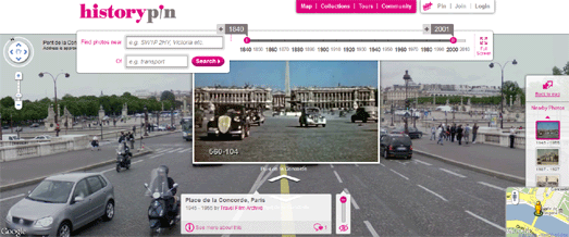

The Chicago Tribune is the latest newspaper to map the 2010 census. The New York Times, The Washington Post, The LA Times and The Texas Tribune have all also created Google Maps of the 2010 U.S. census.

The Chicago Tribune, however, has taken a different approach in its visualisation of the census data. The newspaper's census application uses two Google Maps side-by-side, one showing the population by race in the 2010 census and the other showing the population by race in the 2000 census.

Users can click on any ward in the city to view a breakdown of the ward's census blocks by race. When you click on a ward a breakdown of the population by race is displayed in the map sidebar, allowing you to compare the ward's composition now with how it was composed in 2000.

The Chicago Tribune: Reshaping Chicago

_____________

Friday, July 15, 2011

Google+ on Google Maps


Google Maps may not have much of a presence yet on Google's new social network site Google+ but Google+ now has a huge presence on Google Maps.

Tokyo resident Joseph Tame had the great idea to run a half marathon and at the same time create a large 'G+' geoglyph. Before the run he planned the route out on Google Maps and then used Runkeeper to track his run of the route.

The Art of Running's Google+ Half Marathon

Via: TNW

_____________

Mapping the Popularity of Presidents

Where the Streets Have Your Name is a great application that you can use to create a Google Map showing all the places around the world that have your name.

The app can also be used to do a little research into the worldwide reputation of American presidents. If you enter Kennedy and Nixon into the app you get two very different maps.


Looking at non-English speaking countries is particularly informative. It is less likely that geographical locations in these countries are named after different Kennedys or Nixons.

The results show that continental Europe has commemorated the life of Kennedy by naming numerous places after the president. For some reason Europe has not been so keen to name streets and squares after Richard Nixon.

In fact you have to go back to George Washington to find another American president who has been commemorated in place names outside of the U.S. to quite the same degree as JFK.


Having said all that Nixon is a far more popular place-name than 'Keir' (which features not once in the whole world).

So how well does your name fare?

_____________