

Ten years after Hurricane Katrina struck new Orleans, Esri has released a Story Map which examines the effect of the hurricane on the city and how the city has attempted to rebuild itself.
Katrina +10 includes six main sections; The Katrina Diaspora, Flooding, Physical Damage, Population Shift, Steady Restoration and Neighborhood Reference Map. The 'Flooding' and 'Physical Damage' sections allow you to view maps of the flooding caused by the hurricane and the huge number of buildings in the city which were tagged for demolition in the city after the disaster.
The Katrina Diaspora section shows where the one million displaced Louisiana residents moved to after the hurricane devastated the city. The Population Shift visualizes the effect of this evacuation on each New Orleans neighborhood.
The Steady Restoration section of the map uses postal data to show the percentage of homes in each neighborhood now receiving mail.

In an article entitled, Is New Orleans in danger of turning into a modern-day Atlantis?, The Guardian newspaper places Hurricane Katrina into the context of over a century of engineering projects which are causing the Louisiana wetlands to disappear and which result in New Orleans being more susceptible to flooding.
The article includes historical aerial imagery and maps which show the historical loss of the wetlands and the projected 1,750 square miles that Lousiana is expected to lose in the next 50 years. Louisiana is currently losing a football field of land every 48 minutes.
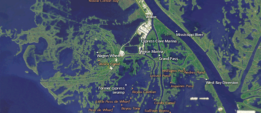
Using historical aerial imagery from NASA and USGS, ProPublica has put together an impressive interactive mapped visualization of the effect of climate change and oil & gas exploration on the state of Louisiana.
Southern Louisiana is losing 16 square miles a year to the Gulf of Mexico. At the heart of ProPublica's map, Losing Ground, is a series of timeline visualizations of historical aerial imagery. These timelines allow you to observe the loss of land in Louisiana by comparing present day aerial imagery with aerial imagery going back to the 1930's.
For example, here is the area of Venice and West Bay as it looked in 1932:

Here's how the same area looks today:
Accompanying the aerial imagery are a series of interviews of people living and working in the affected areas. These interviews are supported by audio files and photos. In combination the audio, photos, interviews and aerial imagery of Louisiana's land loss provide a powerful report into this ongoing environmental disaster.
No comments:
Post a Comment